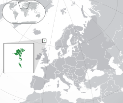
法罗群岛是北欧国家丹麦的海外自治领地。地理位置介乎挪威海和北大西洋中间,处于挪威到冰岛之间距离一半的位置。 法罗群岛陆地面积1,399平方公里,由17个有人岛和若干个无人岛组成,居民共46,662人(2004中期估计),居民多为斯堪的纳维亚人后代,基督教路德教派的成员,官方语言为法罗语和丹麦语。
法罗群岛居民通过投票选出自治议会成员,继而由自治议会选出总理,丹麦政府会向法罗群岛派出高级专员监察自治政府运作,代表女王,并协助处理群岛的对外事务。
了解
[编辑]历史
[编辑]公元600年左右,一批爱尔兰僧侣到此定居。公元9世纪,维京人进占法罗群岛。970年一度成立共和国,但实为苏格兰奥克尼伯爵(Earl of Orkney)的附庸国。1280年随奥克尼群岛成为挪威占领地。1380年随挪威并入丹麦。1650年成为丹麦冯嘉保家族(Von Gabel)的封建领地。1720年划为丹属冰岛辖地。1816年被析置为海外郡。第二次世界大初期丹麦战败后(1940~1945),英军进占法罗群岛。1948年3月30日,法罗群岛获丹麦授与高度自治,成为海外自治领地。
地理
[编辑]法罗群岛是一个由18个主要岛屿组成的岛群,离北欧约655公里,居于挪威海和北大西洋之间,大约在冰岛和挪威的之间处,临近冰岛和苏格兰的埃利安锡尔,地理坐标是62°00′N 06°47′W。其面积为1399平方公里(540平方英里),没有重要的湖泊或河流,并有1,117公里(694英里)长的海岸线其唯一重要的无人岛是Lítla Dímun。最南的岛屿Suðuroy法罗群岛地形大致为崎岖,多石的低山且多石壁。典型的冰川期侵蚀地貌,遍布充分发育的峡湾与巨大金字塔形山体。其地理最高点为Slættaratindur山峰,海拔为882公尺(2,894英尺)。拉斑玄武岩和火山岩为此岛的主要地质,这也是在古近纪时代Thulean高原的一部分。
气候
[编辑]北大西洋暖流经过该地,因此是典型的海洋性亚极地气候。冬季气候并不酷寒,平均温度约摄氏3~4度;夏季气候偏凉,平均温度约摄氏9.5~10.5度。由于是低气压向东北移动的经过路径,法罗群岛常年大风、大雨天气。晴朗天气十分稀少,每年平均260个降雨日,其馀常见阴天。
地区
[编辑]The archipelago is composed of 18 islands covering 1,399 km² (545.3 sq mi) and is 113 km (70 mi) long and 75 km (47 mi) wide. 17 islands are inhabited, leaving just one uninhabited island, the smallest island, Lítla Dímum. There are a lot of smaller islets and skerries around the Faroe Islands. Including the 18 islands there are 779 islands, islets and skerries in the Faroe Islands. A large part of these are around the island Suðuroy, which consists of 263 islets and skerries, including the island itself. The precipitous terrain limits habitation to small coastal lowlands. The islands are connected by tunnels, causeways and a regular public ferry service.

| 北方诸岛 The six Northern islands (Borðoy, Kunoy, Kalsoy, Viðoy, Svínoy and Fugloy) have made up one administrative area since Norse times. The volcanic origin of the Faroe Islands is more pronounced here than anywhere else. The landscape is very dramatic. |
| 东岛 The second largest island. The landscape in the north is very steep. |
| 北斯特罗莫 Streymoy is the largest and main island. The north is less densely populated but there are some wonderful villages. |
| 南斯特罗莫 Here the capital Tórshavn is situated and the area surrounding the capital is where the largest number of people live. |
| 沃加尔岛 Vágar is the third largest island and is where the airport is situated. Mykines, the small island to the west, is well known for its bird life and remote location. |
| 桑岛 The region is made up of three islands with the largest being Sandoy, the other two are Skúvoy and Stóra Dímun. |
| 南岛 The most southerly island and Lítla Dímun - the smallest island, which is uninhabited. |


