
File:Map of the Low German Dialects.svg

此 SVG 檔案的 PNG 預覽的大小:646 × 600 像素。 其他解析度:258 × 240 像素 | 517 × 480 像素 | 827 × 768 像素 | 1,103 × 1,024 像素 | 2,206 × 2,048 像素 | 700 × 650 像素。
原始檔案 (SVG 檔案,表面大小:700 × 650 像素,檔案大小:246 KB)
| 描述 |
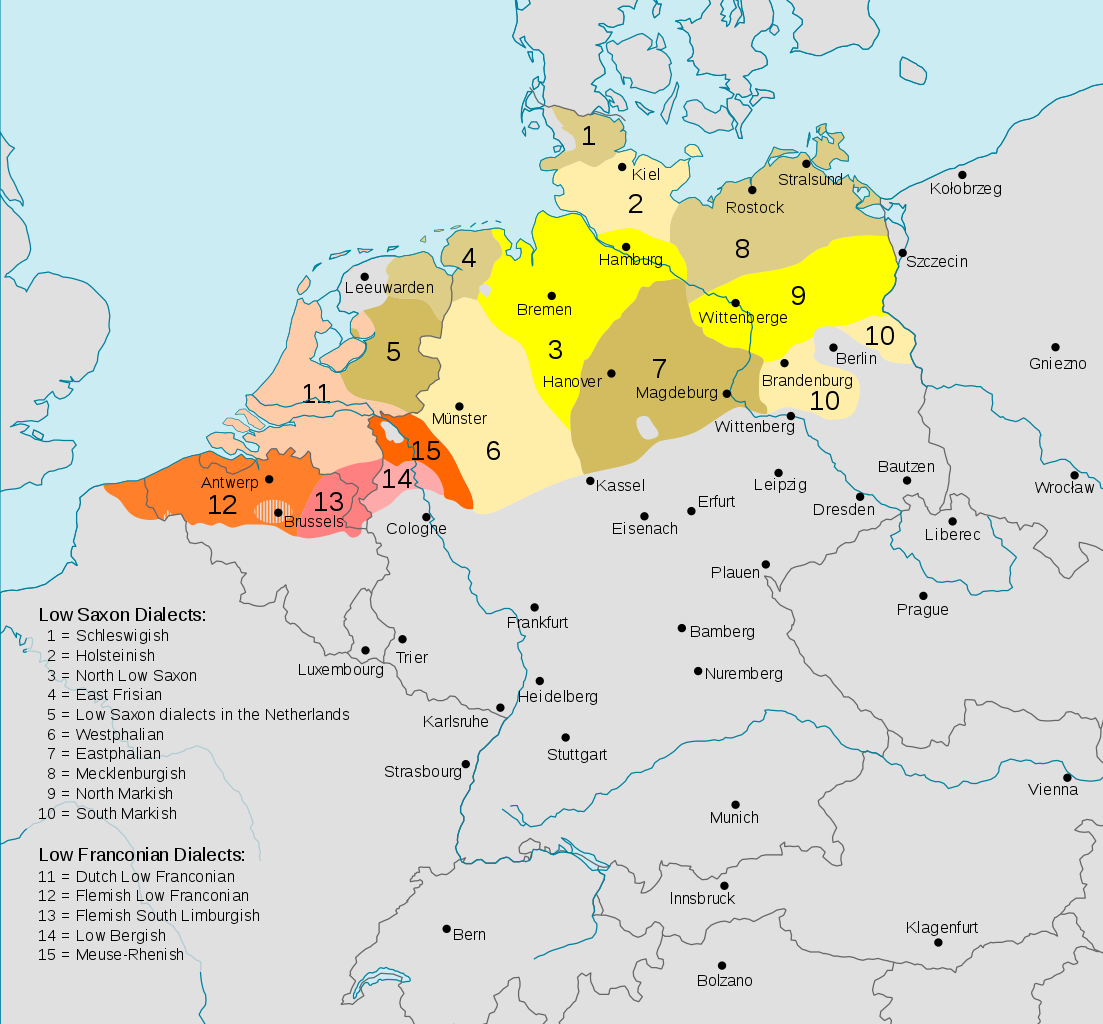
Deutsch: Darstellungskarte der niederdeutschen Mundarten (im weiteren Sinne) seit 1945
English: Distribution map of the Low German (Low Franconian and Low Saxon) languages since 1945. Note however that it's bad:
|
| 日期 | (UTC) |
| 來源 | |
| 作者 |
|
| 其他版本 |
Cropped version without key
|


.svg)

此檔案採用創用CC 姓名標示-相同方式分享 3.0 未在地化版本授權條款。
- 您可以自由:
- 分享 – 複製、發佈和傳播本作品
- 重新修改 – 創作演繹作品
- 惟需遵照下列條件:
- 姓名標示 – 您必須指名出正確的製作者,和提供授權條款的連結,以及表示是否有對內容上做出變更。您可以用任何合理的方式來行動,但不得以任何方式表明授權條款是對您許可或是由您所使用。
- 相同方式分享 – 如果您利用本素材進行再混合、轉換或創作,您必須基於如同原先的相同或兼容的條款,來分布您的貢獻成品。
原始上傳日誌
This image is a derivative work of the following images:
- File:Verbreitungsgebiet_der_heutigen_niederdeutschen_Mundarten.PNG licensed with PD-user-de, PD-user-w
- 2008-08-08T10:33:32Z Gruna 1 652x652 (37059 Bytes) See previous version
- 2006-04-14T17:48:45Z Vonvon 652x652 (36806 Bytes) * created on de.wikipedia.org by [[:de:Benutzer:Postmann Michael]] on 31 December 2004 * Beschreibung:Darstellungskarte der niederdeutschen Mundarten seit 1945 (''Location Map of the Low Germanic languages'') * original licen
- File:Europe.svg licensed with PD-USGov-CIA-WF
Uploaded with derivativeFX
檔案歷史
點選日期/時間以檢視該時間的檔案版本。
| 日期/時間 | 縮圖 | 尺寸 | 使用者 | 備註 | |
|---|---|---|---|---|---|
| 目前 | 2017年12月12日 (二) 02:54 | | 700 × 650(246 KB) | Alphathon | Border in Lake Geneva and the Rhine delta |
| 2017年12月12日 (二) 02:24 |  | 700 × 650(245 KB) | Alphathon | Corrected some settlement placements and Anglicised names | |
| 2017年12月12日 (二) 01:04 |  | 700 × 650(245 KB) | Alphathon | Correction (Holland → the Netherlands) | |
| 2015年10月28日 (三) 05:54 |  | 700 × 650(266 KB) | Alphathon | Corrected some minor errors and cropped | |
| 2011年2月7日 (一) 22:30 |  | 789 × 852(292 KB) | Alphathon | Missed some in previous edit | |
| 2011年2月7日 (一) 22:29 |  | 789 × 852(292 KB) | Alphathon | Minor font change (so it renders properly in previews etc.) | |
| 2011年2月7日 (一) 22:14 |  | 789 × 852(290 KB) | Alphathon | Translated into English since it has an English title. German Version will be re-uploaded under a different name | |
| 2011年2月7日 (一) 09:15 |  | 789 × 852(285 KB) | Alphathon | {{Information |Description={{de|Darstellungskarte der niederdeutschen Mundarten seit 1945}} {{en|Distribution map of the Low Saxon and Low Franconian languages since 1945}} |Source=*File:Verbreitungsgebiet_der_heutigen_niederdeutschen_Mundarten.PNG |
檔案用途
下列頁面有用到此檔案:
全域檔案使用狀況
以下其他 wiki 使用了這個檔案:
- an.wikipedia.org 的使用狀況
- ar.wikipedia.org 的使用狀況
- en.wikipedia.org 的使用狀況
- en.wikivoyage.org 的使用狀況
- nds-nl.wikipedia.org 的使用狀況
- nl.wikipedia.org 的使用狀況
- ru.wikipedia.org 的使用狀況
- simple.wikipedia.org 的使用狀況