
File:Map of the Low German Dialects.svg

此SVG文件的PNG预览的大小:646 × 600像素。 其他分辨率:258 × 240像素 | 517 × 480像素 | 827 × 768像素 | 1,103 × 1,024像素 | 2,206 × 2,048像素 | 700 × 650像素。
原始文件 (SVG文件,尺寸为700 × 650像素,文件大小:246 KB)
| 描述 |
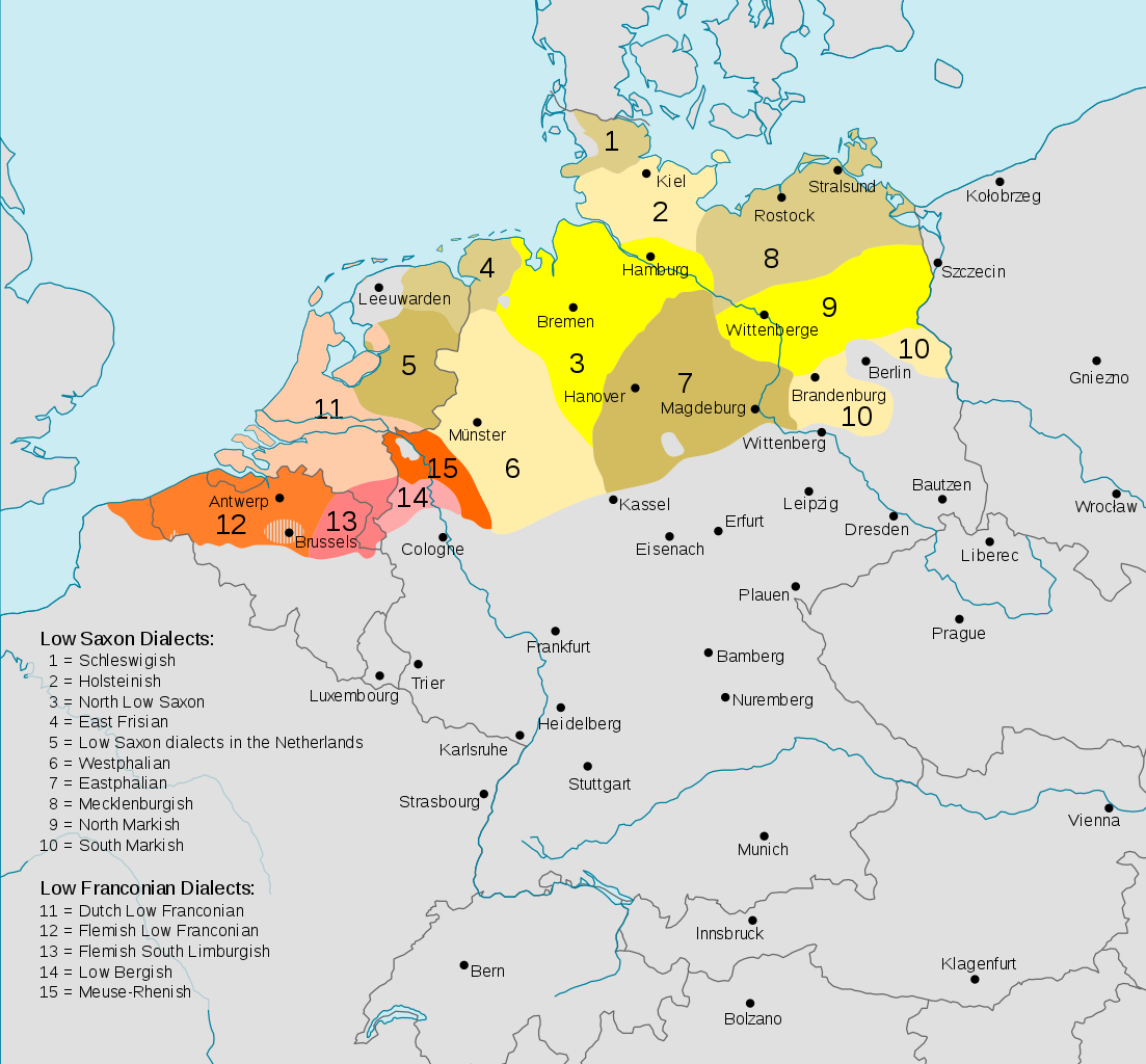
Deutsch: Darstellungskarte der niederdeutschen Mundarten (im weiteren Sinne) seit 1945
English: Distribution map of the Low German (Low Franconian and Low Saxon) languages since 1945. Note however that it's bad:
|
| 日期 | (UTC) |
| 来源 | |
| 作者 |
|
| 其他版本 |
Cropped version without key
|


.svg)

本文件采用知识共享署名-相同方式共享 3.0 未本地化版本许可协议授权。
- 您可以自由地:
- 共享 – 复制、发行并传播本作品
- 修改 – 改编作品
- 惟须遵守下列条件:
- 署名 – 您必须对作品进行署名,提供授权条款的链接,并说明是否对原始内容进行了更改。您可以用任何合理的方式来署名,但不得以任何方式表明许可人认可您或您的使用。
- 相同方式共享 – 如果您再混合、转换或者基于本作品进行创作,您必须以与原先许可协议相同或相兼容的许可协议分发您贡献的作品。
原始上传日志
This image is a derivative work of the following images:
- File:Verbreitungsgebiet_der_heutigen_niederdeutschen_Mundarten.PNG licensed with PD-user-de, PD-user-w
- 2008-08-08T10:33:32Z Gruna 1 652x652 (37059 Bytes) See previous version
- 2006-04-14T17:48:45Z Vonvon 652x652 (36806 Bytes) * created on de.wikipedia.org by [[:de:Benutzer:Postmann Michael]] on 31 December 2004 * Beschreibung:Darstellungskarte der niederdeutschen Mundarten seit 1945 (''Location Map of the Low Germanic languages'') * original licen
- File:Europe.svg licensed with PD-USGov-CIA-WF
Uploaded with derivativeFX
文件历史
点击某个日期/时间查看对应时刻的文件。
| 日期/时间 | 缩略图 | 大小 | 用户 | 备注 | |
|---|---|---|---|---|---|
| 当前 | 2017年12月12日 (二) 02:54 | | 700 × 650(246 KB) | Alphathon | Border in Lake Geneva and the Rhine delta |
| 2017年12月12日 (二) 02:24 |  | 700 × 650(245 KB) | Alphathon | Corrected some settlement placements and Anglicised names | |
| 2017年12月12日 (二) 01:04 |  | 700 × 650(245 KB) | Alphathon | Correction (Holland → the Netherlands) | |
| 2015年10月28日 (三) 05:54 |  | 700 × 650(266 KB) | Alphathon | Corrected some minor errors and cropped | |
| 2011年2月7日 (一) 22:30 |  | 789 × 852(292 KB) | Alphathon | Missed some in previous edit | |
| 2011年2月7日 (一) 22:29 |  | 789 × 852(292 KB) | Alphathon | Minor font change (so it renders properly in previews etc.) | |
| 2011年2月7日 (一) 22:14 |  | 789 × 852(290 KB) | Alphathon | Translated into English since it has an English title. German Version will be re-uploaded under a different name | |
| 2011年2月7日 (一) 09:15 |  | 789 × 852(285 KB) | Alphathon | {{Information |Description={{de|Darstellungskarte der niederdeutschen Mundarten seit 1945}} {{en|Distribution map of the Low Saxon and Low Franconian languages since 1945}} |Source=*File:Verbreitungsgebiet_der_heutigen_niederdeutschen_Mundarten.PNG |
文件用途
以下页面使用本文件:
全域文件用途
以下其他wiki使用此文件:
- an.wikipedia.org上的用途
- ar.wikipedia.org上的用途
- en.wikipedia.org上的用途
- en.wikivoyage.org上的用途
- nds-nl.wikipedia.org上的用途
- nl.wikipedia.org上的用途
- ru.wikipedia.org上的用途
- simple.wikipedia.org上的用途