
File:Location San Marino Europe.svg

此 SVG 檔案的 PNG 預覽的大小:713 × 600 像素。 其他解析度:285 × 240 像素 | 571 × 480 像素 | 913 × 768 像素 | 1,218 × 1,024 像素 | 2,435 × 2,048 像素 | 2,045 × 1,720 像素。
原始檔案 (SVG 檔案,表面大小:2,045 × 1,720 像素,檔案大小:4.51 MB)
摘要
| 描述 |
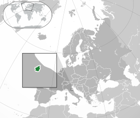
English: Location of San Marino in Europe.
Italiano: Posizione di San Marino in Europa. |
| 日期 | (UTC) |
| 來源 |
本檔案衍生自: |
| 作者 |
授權條款
此檔案採用創用CC 姓名標示-相同方式分享 3.0 未在地化版本授權條款。
- 您可以自由:
- 分享 – 複製、發佈和傳播本作品
- 重新修改 – 創作演繹作品
- 惟需遵照下列條件:
- 姓名標示 – 您必須指名出正確的製作者,和提供授權條款的連結,以及表示是否有對內容上做出變更。您可以用任何合理的方式來行動,但不得以任何方式表明授權條款是對您許可或是由您所使用。
- 相同方式分享 – 如果您利用本素材進行再混合、轉換或創作,您必須基於如同原先的相同或兼容的條款,來分布您的貢獻成品。
原始上傳日誌
This image is a derivative work of the following images:
- File:Location San Marino Europe.png licensed with Cc-by-sa-3.0, GFDL
- 2013-07-02T00:40:32Z Klodde 2056x1800 (455515 Bytes) Bigger
- 2009-06-30T03:08:02Z Bosonic dressing 2056x1800 (378475 Bytes) {{Information |Description={{en|1=San Marino (dark green) / Europe (dark grey); inspired by and consistent with general country locator maps by User:Vardion, et al}} |Source=Own work by uploader |Author=[[User:Bosonic dressin
- File:Europe-Faroe Islands.svg licensed with Cc-by-sa-3.0
- 2020-02-06T08:22:11Z Rob984 2045x1720 (7791783 Bytes) General improvements. Base: [[:File:Location European nation states.svg]]. Zoom insert derived from [[:File:Map of the Faroe Islands de.svg]].
- 2011-02-22T11:24:44Z Chipmunkdavis 2045x1720 (2329810 Bytes) {{Information |Description={{en|1={{Europe-SVG-en|Northern Cyprus}}}} {{en|1=The Full Map of Jersey}} |Source=*[[:File:Europe-Jersey.svg|]] |Date=2011-02-22 11:23 (UTC) |Author=*[[:File:Europe-Jersey.svg|]]: *[[:File:Europe-N
- File:Location European nation states.svg licensed with Cc-by-sa-3.0-migrated, GFDL
- 2020-05-22T17:41:59Z Thayts 2045x1720 (2972998 Bytes) The island of Borkum belongs to Germany, not the Netherlands
- 2020-02-06T03:54:48Z Rob984 2045x1720 (2936560 Bytes) Huge code cleanup + fixed XML errors
- 2020-02-02T06:21:11Z Rob984 2045x1720 (5974727 Bytes) Per COM:OVERWRITE, since this file conforms with UN: Added Morocco-Western Sahara border. Removed border showing Israeli-occupied Golan Heights.
- 2020-02-01T02:16:25Z Rob984 2045x1720 (5937232 Bytes) Fixed Flevoland in the Netherlands, and other minor inaccuracies.
- 2019-12-29T02:09:08Z Rob984 2045x1720 (5955906 Bytes) Minor corrections to shading of islands.
- 2019-12-29T00:50:58Z Rob984 2045x1720 (5955939 Bytes) Per original file: a few disputed areas I changed by accident.
- 2019-12-29T00:10:39Z Rob984 2045x1720 (5858427 Bytes) Subtly revised the pan/scale in order to show the Flores Island in the Azores, and Franz Josef Land (the Russia archipelago north east of Svalbard). Note: the image dimensions remain the same.
- 2017-11-19T14:03:18Z Giorgi Balakhadze 2045x1720 (7667567 Bytes) Rv of Rob984 edits per COM:OVERWRITE, the original file by Ssolbergj had no conflict regions
- 2017-08-29T17:14:14Z Бровар 2045x1720 (7708628 Bytes) Reverted to version as of 01:26, 10 March 2017 (UTC)
- 2017-08-29T17:09:09Z Бровар 512x431 (772453 Bytes) Crimea is not an island, it is a Ukrainian peninsula.
- 2017-03-10T01:26:45Z Geom10 2045x1720 (7708628 Bytes) fixed disputed borders
- 2016-08-09T23:51:53Z Rob984 2045x1720 (7694883 Bytes) More contrast between Europe and other areas+ocean. Also changed to neutral grey rather than blue tinted.
- 2015-05-18T12:40:29Z Denniss 2045x1720 (7737776 Bytes) Reverted to version as of 16:09, 19 August 2014
- 2015-05-18T10:47:19Z Ercwlff 2045x1720 (748293 Bytes) Reverted to version as of 15:55, 9 October 2010
- 2014-08-19T16:09:45Z Rob984 2045x1720 (7737776 Bytes) Minor
- 2014-08-06T15:09:11Z Rob984 2045x1720 (7737748 Bytes) Improved version: More accurate coastline, borders, etc. Added Gradient and Longitude and latitude lines.
- 2010-10-09T15:55:16Z LX 2045x1720 (748293 Bytes) Reverted sockpuppet edits to version as of 15:03, 11 November 2009
- 2010-10-02T06:27:34Z Lartyo 2045x1720 (730891 Bytes) Reverted to version as of 20:37, 18 October 2009
- 2009-11-11T15:03:57Z NuclearVacuum 2045x1720 (748293 Bytes) minor
- 2009-11-11T14:59:54Z NuclearVacuum 2045x1720 (733426 Bytes) territorial fixes
- 2009-10-18T20:37:51Z NuclearVacuum 2045x1720 (730891 Bytes) several countries did not include all its territories
- 2008-12-04T00:44:42Z Ssolbergj 2045x1720 (726069 Bytes) Kosovo
- 2008-06-20T13:09:36Z Ssolbergj 2045x1720 (724181 Bytes) Reverted to version as of 00:57, 12 June 2008
- 2008-06-19T17:59:14Z Ssolbergj 2045x1720 (719110 Bytes) {{Information |Description= |Source= |Date= |Author= |Permission= |other_versions= }}
- 2008-06-12T00:57:39Z Ssolbergj 2045x1720 (724181 Bytes) {{Information |Description={{en|1=SVG map of Europe. Borders of nation states.}} {{no|1=SVG-kart over Europa. Nasjonstatlige grenser.}} |Source=[[:Image:Location Spain EU Europe 1.svg]] |Author=[[:en:User:Ssolbergj|Ssolbergj]
Uploaded with derivativeFX
檔案歷史
點選日期/時間以檢視該時間的檔案版本。
| 日期/時間 | 縮圖 | 尺寸 | 使用者 | 備註 | |
|---|---|---|---|---|---|
| 目前 | 2023年2月25日 (六) 04:44 | | 2,045 × 1,720(4.51 MB) | Arrow303 | contorni |
| 2023年2月25日 (六) 04:43 |  | 2,045 × 1,720(4.51 MB) | Arrow303 | Corretto errore | |
| 2023年2月25日 (六) 04:40 |  | 2,045 × 1,720(4.51 MB) | Arrow303 | == {{int:filedesc}} == {{Information |Description={{en|1=Location of San Marino in Europe.}} {{it|1=Posizione di San Marino in Europa.}} |Source={{Derived from|Location San Marino Europe.png|Europe-Faroe Islands.svg|Location European nation states.svg|display=50}} |Date=2023-02-24 20:32 (UTC) |Author=* File:Location San Marino Europe.png: Bosonic dressing * File:Europe-Faroe Islands.svg: [[Us... |
檔案用途
下列頁面有用到此檔案:
全域檔案使用狀況
以下其他 wiki 使用了這個檔案:
- af.wikipedia.org 的使用狀況
- ar.wikipedia.org 的使用狀況
- arz.wikipedia.org 的使用狀況
- ast.wikipedia.org 的使用狀況
- az.wikipedia.org 的使用狀況
- ca.wikipedia.org 的使用狀況
- ce.wikipedia.org 的使用狀況
- diq.wikipedia.org 的使用狀況
- fa.wikipedia.org 的使用狀況
- fr.wikipedia.org 的使用狀況
- fr.wikinews.org 的使用狀況
- ga.wikipedia.org 的使用狀況
- gl.wikipedia.org 的使用狀況
- ha.wikipedia.org 的使用狀況
- hy.wikipedia.org 的使用狀況
- ia.wikipedia.org 的使用狀況
- incubator.wikimedia.org 的使用狀況
- it.wikipedia.org 的使用狀況
- kab.wikipedia.org 的使用狀況
- ku.wikipedia.org 的使用狀況
- la.wikipedia.org 的使用狀況
- mdf.wikipedia.org 的使用狀況
- nds.wikipedia.org 的使用狀況
- oc.wikipedia.org 的使用狀況
- olo.wikipedia.org 的使用狀況
- ru.wikipedia.org 的使用狀況
- ru.wikinews.org 的使用狀況
- sl.wikipedia.org 的使用狀況
- ur.wikipedia.org 的使用狀況
- www.wikidata.org 的使用狀況