
File:Bayarea map.svg

此 SVG 檔案的 PNG 預覽的大小:533 × 599 像素。 其他解析度:213 × 240 像素 | 427 × 480 像素 | 683 × 768 像素 | 911 × 1,024 像素 | 1,822 × 2,048 像素 | 693 × 779 像素。
原始檔案 (SVG 檔案,表面大小:693 × 779 像素,檔案大小:296 KB)
摘要
| 描述 |
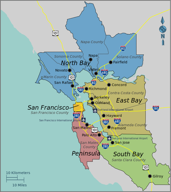
English: Bay Area Regions Map, Bay Area (California). |
| 日期 | |
| 來源 | Open Street Map and the PD Wikivoyage template |
| 作者 | PerryPlanet |
| This work contains information from OpenStreetMap, which is made available under the Open Database License (ODbL).
The ODbL does not require any particular license for maps produced from ODbL data. Prior to 1 August 2020, map tiles produced by the OpenStreetMap Foundation were licensed under the CC-BY-SA-2.0 license. Maps produced by other people may be subject to other licences. |
本vector image使用Inkscape創作 .
授權條款
| 此作品已由其作者,User: (WT-shared) PerryPlanet at wts 維基導遊,釋出至公有領域。此授權條款在全世界均適用。 這可能在某些國家不合法,如果是的話: User: (WT-shared) PerryPlanet at wts 維基導遊授予任何人有權利使用此作品於任何用途,除受法律約束外,不受任何限制。
|
原始上傳日誌
| This file was imported from Wikivoyage WTS. |
The original description page was here. All following user names refer to wts.wikivoyage-old.
- 2010-10-17 03:38 (WT-shared) PerryPlanet[失效連結] 744×1052 (677515 bytes) {{Imagecredit|credit=PerryPlanet|captureDate=10/16/2010|location=Bay Area (California)|source=Open Street Map and the PD Wikitravel template (Import from wikitravel.org/shared)
檔案歷史
點選日期/時間以檢視該時間的檔案版本。
| 日期/時間 | 縮圖 | 尺寸 | 使用者 | 備註 | |
|---|---|---|---|---|---|
| 目前 | 2015年11月21日 (六) 18:06 | | 693 × 779(296 KB) | Hdamm | fixed image dimensions, clean up |
| 2012年11月18日 (日) 04:49 |  | 744 × 1,052(662 KB) | MGA73bot2 | {{BotMoveToCommons|wts.oldwikivoyage|year={{subst:CURRENTYEAR}}|month={{subst:CURRENTMONTHNAME}}|day={{subst:CURRENTDAY}}}} == {{int:filedesc}} == {{Information |description=Bay Area Regions Map. , Bay Area (California) * Map of: Bay Area (California)... |
檔案用途
下列頁面有用到此檔案:
全域檔案使用狀況
以下其他 wiki 使用了這個檔案:
- de.wikivoyage.org 的使用狀況
- en.wikivoyage.org 的使用狀況