
File:Malawi map.png
本预览的尺寸:366 × 600像素。 其他分辨率:146 × 240像素 | 625 × 1,024像素。
原始文件 (625 × 1,024像素,文件大小:280 KB,MIME类型:image/png)
摘要
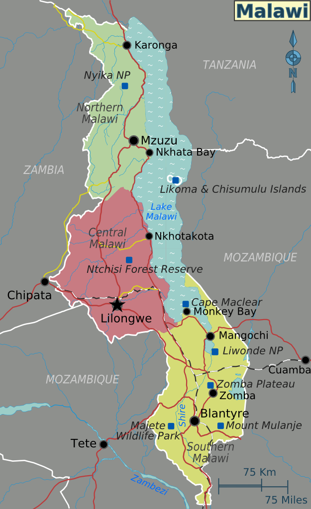
| 描述 | Map of Malawi with regions, major cities and other destinations noted (for use on Wikivoyage), English version | ||||
| 日期 | |||||
| 来源 |
自己的作品 based on the UN map of Malawi
|
||||
| 作者 | Shaund | ||||
| 其他版本 |
许可协议
This file is licensed under the Creative Commons Attribution-Share Alike 4.0 International, 3.0 Unported, 2.5 Generic, 2.0 Generic and 1.0 Generic license.
- 您可以自由地:
- 共享 – 复制、发行并传播本作品
- 修改 – 改编作品
- 惟须遵守下列条件:
- 署名 – 您必须对作品进行署名,提供授权条款的链接,并说明是否对原始内容进行了更改。您可以用任何合理的方式来署名,但不得以任何方式表明许可人认可您或您的使用。
- 相同方式共享 – 如果您再混合、转换或者基于本作品进行创作,您必须以与原先许可协议相同或相兼容的许可协议分发您贡献的作品。
原始上传日志
| This file was imported from Wikivoyage WTS. |
The original description page was here. All following user names refer to wts.wikivoyage-old.
- 2010-02-01 05:46 (WT-shared) Shaund archive copy at the Wayback Machine 625×1024 (286320 bytes) {{Imagecredit|credit=[[User:Shaund|Shaund]]|captureDate=31 Jan 2010|location=Malawi|source=[[Image:Malawi regions.svg]]|caption=|description (Import from wikitravel.org/shared)
文件历史
点击某个日期/时间查看对应时刻的文件。
| 日期/时间 | 缩略图 | 大小 | 用户 | 备注 | |
|---|---|---|---|---|---|
| 当前 | 2012年11月18日 (日) 08:45 | | 625 × 1,024(280 KB) | MGA73bot2 | {{BotMoveToCommons|wts.oldwikivoyage|year={{subst:CURRENTYEAR}}|month={{subst:CURRENTMONTHNAME}}|day={{subst:CURRENTDAY}}}} == {{int:filedesc}} == {{Information |description=Map of Malawi. Map of Malawi with regions, major cities and other destinations... |
文件用途
以下页面使用本文件:
全域文件用途
以下其他wiki使用此文件:
- en.wikipedia.org上的用途
- en.wikivoyage.org上的用途
- es.wikipedia.org上的用途
- fr.wikipedia.org上的用途
- he.wikivoyage.org上的用途
- incubator.wikimedia.org上的用途
- it.wikivoyage.org上的用途
- ja.wikivoyage.org上的用途
- tum.wikipedia.org上的用途
- uk.wikipedia.org上的用途
- vi.wikivoyage.org上的用途