
File:Somaliland regions map.png
預覽大小:800 × 513 像素。 其他解析度:320 × 205 像素 | 640 × 410 像素 | 1,024 × 657 像素 | 1,280 × 821 像素 | 1,600 × 1,026 像素。
原始檔案 (1,600 × 1,026 像素,檔案大小:556 KB,MIME 類型:image/png)

|
此檔案是透過機器人腳本從wts.oldwikivoyage移動到維基共享資源的。來源中的所有資訊均已保留,但仍需要人工的審閱。部分或所有的資訊可能會出現在錯誤的區域;只有在經過審閱並修正需改正的錯誤後,此檔案的相關資訊才能視為可使用。當審閱結束後,請移除本模板,更詳細的資訊參見下方。 現在就開始檢查! |
摘要
| 描述 |
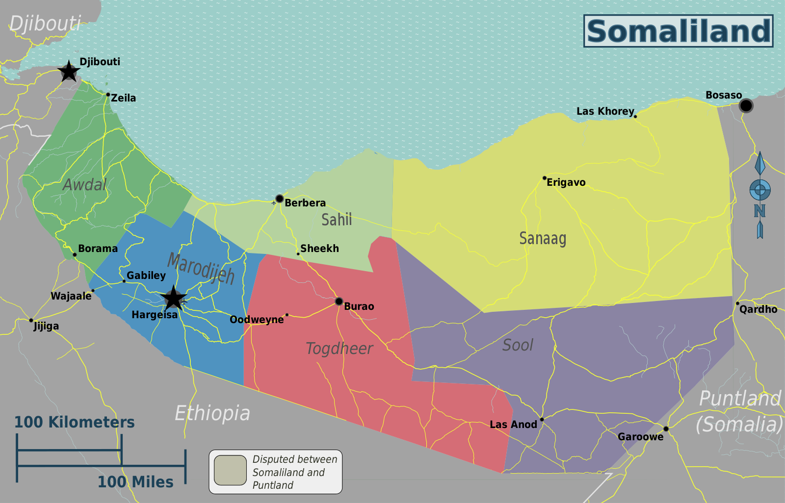
English: Somaliland regions map. English version, Somaliland
|
| 日期 | |
| 來源 | File:Somaliland regions map.svg |
| 作者 | Peter Fitzgerald, OpenStreetMap [1] |
授權條款
此檔案採用共享創意 姓名標示-相同方式分享 2.0 通用版授權條款。
- 您可以自由:
- 分享 – 複製、發佈和傳播本作品
- 重新修改 – 創作演繹作品
- 惟需遵照下列條件:
- 姓名標示 – 您必須指名出正確的製作者,和提供授權條款的連結,以及表示是否有對內容上做出變更。您可以用任何合理的方式來行動,但不得以任何方式表明授權條款是對您許可或是由您所使用。
- 相同方式分享 – 如果您利用本素材進行再混合、轉換或創作,您必須基於如同原先的相同或兼容的條款,來分布您的貢獻成品。
原始上傳日誌
| This file was imported from Wikivoyage WTS. |
原始描述頁面位於這裡。下列使用者名稱均來自wts.wikivoyage-old。
- 2012-10-30 01:51 Peterfitzgerald archive copy at the Wayback Machine 3008×1928 (1130785 bytes) {{Imagecredit|credit=Peter Fitzgerald, OpenStreetMap [http://openstreetmap.org]|captureDate=29 October 2012|location=Somaliland|source=[[:File:Somaliland regions map.svg]]|caption=Somaliland regions map|description=English version}}{{Map|Somaliland}}
檔案歷史
點選日期/時間以檢視該時間的檔案版本。
| 日期/時間 | 縮圖 | 尺寸 | 用戶 | 備註 | |
|---|---|---|---|---|---|
| 目前 | 2021年5月3日 (一) 06:40 | | 1,600 × 1,026(556 KB) | Siirski | update borders to show Sahil region and corrected eastern border |
| 2020年6月21日 (日) 02:03 |  | 3,008 × 1,928(1.08 MB) | Kzl55 | Reverted to version as of 02:45, 18 November 2012 (UTC) Restored long-standing stable version, the map is of regions within Somaliland | |
| 2020年6月17日 (三) 00:07 |  | 800 × 513(296 KB) | Meelpringthusss | highlighted disputed area | |
| 2012年11月18日 (日) 10:45 |  | 3,008 × 1,928(1.08 MB) | MGA73bot2 | {{BotMoveToCommons|wts.oldwikivoyage|year={{subst:CURRENTYEAR}}|month={{subst:CURRENTMONTHNAME}}|day={{subst:CURRENTDAY}}}} == {{int:filedesc}} == {{Information |description=Somaliland regions map. English version, Somaliland * Map of: Somaliland¤ |da... |
檔案用途
沒有使用此檔案的頁面。
全域檔案使用狀況
以下其他 wiki 使用了這個檔案:
- en.wikipedia.org 的使用狀況
- fr.wikivoyage.org 的使用狀況
- incubator.wikimedia.org 的使用狀況
- it.wikivoyage.org 的使用狀況
- vi.wikivoyage.org 的使用狀況