
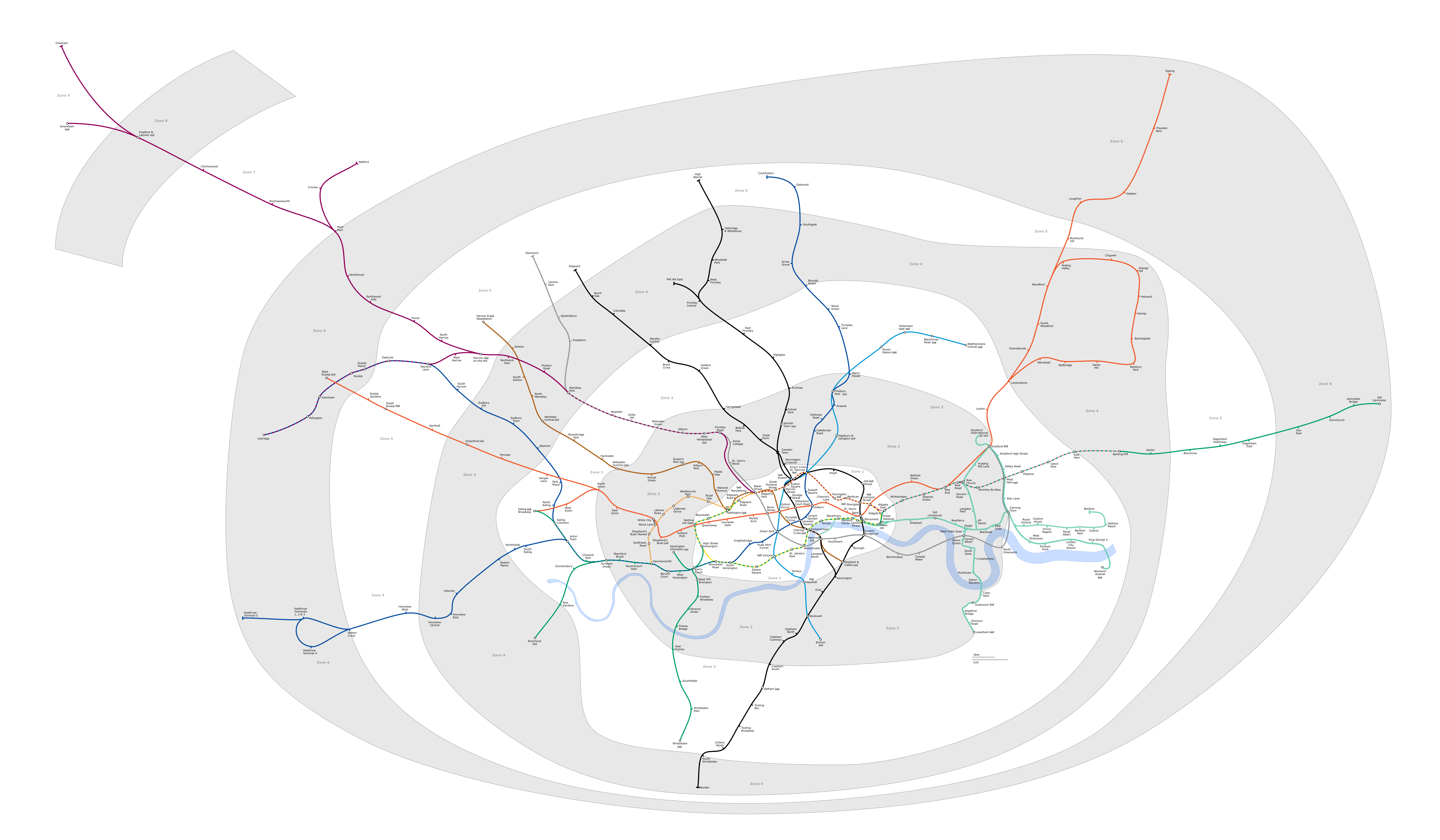
File:London Underground full map.png
預覽大小:800 × 467 像素。 其他解析度:320 × 187 像素 | 640 × 373 像素 | 1,024 × 597 像素 | 1,280 × 747 像素 | 2,560 × 1,493 像素 | 6,000 × 3,500 像素。
原始檔案 (6,000 × 3,500 像素,檔案大小:1.36 MB,MIME 類型:image/png)
Generated as part of the London Underground geographic maps project by software written by ed g2s • talk and James D. Forrester utilising GPS data.
NB: Routes between stations are interpolated and may not be geographically accurate

|
已授權您依據自由軟體基金會發行的無固定段落、封面文字和封底文字GNU自由文件授權條款1.2版或任意後續版本,對本檔進行複製、傳播和/或修改。該協議的副本列在GNU自由文件授權條款中。 |
| 此檔案採用共享創意 姓名標示-相同方式分享 3.0 未在地化版本授權條款。 | ||
| ||
| 已新增授權條款標題至此檔案,作為GFDL授權更新的一部份。 |
Upload log
Latest versions of this file are uploaded from wts.wikivoyage-old.org.
The original description page was here. All following user names refer to wts.wikivoyage-old.
org:
- 2010-02-11 19:08:44 4100×2374 (1,076,793 bytes) (WT-shared) Peterfitzgerald attempted fix (Import from wikitravel.org/shared)
- 2009-12-20 21:41:21 4000×2312 (827,759 bytes) (WT-shared) Peterfitzgerald increase resolution (Import from wikitravel.org/shared)
- 2009-12-20 00:59:42 3000×1734 (571,486 bytes) (WT-shared) Peterfitzgerald == Summary == {{Imagecredit|credit=[[:wmc:User:DavidCane]], [[:wmc:User:Ed g2s]], Peter Fitzgerald|captureDate=19 December 2009|location=Lon (Import from wikitravel.org/shared)
檔案歷史
點選日期/時間以檢視該時間的檔案版本。
| 日期/時間 | 縮圖 | 尺寸 | 用戶 | 備註 | |
|---|---|---|---|---|---|
| 目前 | 2018年2月5日 (一) 07:23 | | 6,000 × 3,500(1.36 MB) | DavidCane | Amend to correspond to svg version |
| 2015年10月8日 (四) 21:04 |  | 6,000 × 3,500(1.1 MB) | RokerHRO | optipng -o7 -i0 -zc1-9 -zm1-9 -zs0-3 -f0-5 → 19.47% decrease | |
| 2014年8月12日 (二) 11:26 |  | 6,000 × 3,500(1.36 MB) | Jc86035 | Updated again | |
| 2014年8月8日 (五) 20:07 |  | 6,000 × 3,500(1.35 MB) | Jc86035 | again, updated from SVG version | |
| 2013年12月3日 (二) 23:15 |  | 6,000 × 3,500(1.35 MB) | Jc86035 | Updated from SVG at File:London Underground full map.svg | |
| 2012年11月22日 (四) 16:42 |  | 4,000 × 2,320(274 KB) | Atsirlin | Reverted to version as of 01:42, 6 January 2007: OK, importing new versions was a bad idea... | |
| 2012年11月22日 (四) 16:32 |  | 4,100 × 2,374(1.03 MB) | OgreBot | (BOT): Uploading old version of file from wts.wikivoyage-old; originally uploaded on 2010-02-11 19:08:44 by (WT-shared) Peterfitzgerald | |
| 2012年11月22日 (四) 16:32 |  | 4,000 × 2,312(808 KB) | OgreBot | (BOT): Uploading old version of file from wts.wikivoyage-old; originally uploaded on 2009-12-20 21:41:21 by (WT-shared) Peterfitzgerald | |
| 2012年11月22日 (四) 16:32 |  | 3,000 × 1,734(558 KB) | OgreBot | (BOT): Uploading old version of file from wts.wikivoyage-old; originally uploaded on 2009-12-20 00:59:42 by (WT-shared) Peterfitzgerald | |
| 2007年1月6日 (六) 09:42 |  | 4,000 × 2,320(274 KB) | Ed g2s | new zone 4 boundary |
檔案用途
下列頁面有用到此檔案:
全域檔案使用狀況
以下其他 wiki 使用了這個檔案:
- da.wikipedia.org 的使用狀況
- en.wikipedia.org 的使用狀況
- en.wikivoyage.org 的使用狀況
- es.wikipedia.org 的使用狀況
- fr.wikivoyage.org 的使用狀況
- he.wikipedia.org 的使用狀況
- hi.wikipedia.org 的使用狀況
- hu.wikipedia.org 的使用狀況
- ja.wikipedia.org 的使用狀況
- ko.wikipedia.org 的使用狀況
- nap.wikipedia.org 的使用狀況
- nl.wikipedia.org 的使用狀況
- Acton Town (metrostation)
- Alperton (metrostation)
- Amersham (metrostation)
- Arnos Grove (metrostation)
- Dagenham East (metrostation)
- Debden (metrostation)
- Dagenham Heathway (metrostation)
- Fairlop (metrostation)
- Finchley Central (metrostation)
- Ickenham (metrostation)
- Station Balham
- Barkingside (metrostation)
- Becontree (metrostation)
- Boston Manor (metrostation)
- Bounds Green (metrostation)
- Brent Cross (metrostation)
- Buckhurst Hill (metrostation)
- Burnt Oak (metrostation)
- Oakwood (metrostation)
- Osterley (metrostation)
- Stanmore (metrostation)
- Gants Hill (metrostation)
- Grange Hill (metrostation)
- Canons Park (metrostation)
- Station Chalfont & Latimer
- Chesham (metrostation)
- Chigwell (metrostation)
- Station Chorleywood
- Cockfosters (metrostation)
- Colindale (metrostation)
- Colliers Wood (metrostation)
- Croxley (metrostation)
- Custom House for ExCeL
- Cyprus (metrostation)
檢視此檔案的更多全域使用狀況。