
File:Iceland Mid-Atlantic Ridge map.svg

此 SVG 檔案的 PNG 預覽的大小:376 × 390 像素。 其他解析度:231 × 240 像素 | 463 × 480 像素 | 740 × 768 像素 | 987 × 1,024 像素 | 1,974 × 2,048 像素。
原始檔案 (SVG 檔案,表面大小:376 × 390 像素,檔案大小:129 KB)
摘要
| 描述 | |
| 日期 | |
| 來源 | http://pubs.usgs.gov/gip/dynamic/understanding.html |
| 作者 | http://pubs.usgs.gov/gip/dynamic/understanding.html |
| 其他版本 |
|


授權條款
|
|
| 註解 | 該圖片含有註解:在維基媒體共享資源上查看註解 |
檔案歷史
點選日期/時間以檢視該時間的檔案版本。
| 日期/時間 | 縮圖 | 尺寸 | 用戶 | 備註 | |
|---|---|---|---|---|---|
| 目前 | 2014年1月11日 (六) 02:48 | | 376 × 390(129 KB) | Amitchell125 | text improved |
| 2010年2月26日 (五) 22:42 |  | 376 × 390(68 KB) | Beao | Tweak. | |
| 2010年2月26日 (五) 22:40 |  | 376 × 390(68 KB) | Beao | Tweak. | |
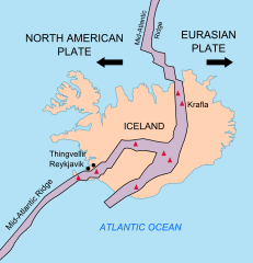
| 2010年2月26日 (五) 22:37 |  | 376 × 390(68 KB) | Beao | == Summary == {{Information |Description={{en|1=Map showing the Mid-Atlantic Ridge splitting Iceland and separating the North American and Eurasian Plates. The map also shows Reykjavik, the capital of Iceland, the Thingvellir area, and the locations of so |
檔案用途
下列頁面有用到此檔案:
全域檔案使用狀況
以下其他 wiki 使用了這個檔案:
- be-tarask.wikipedia.org 的使用狀況
- bn.wikipedia.org 的使用狀況
- ca.wikipedia.org 的使用狀況
- en.wikipedia.org 的使用狀況
- en.wikivoyage.org 的使用狀況
- fi.wikipedia.org 的使用狀況
- hr.wikipedia.org 的使用狀況
- id.wikipedia.org 的使用狀況
- it.wikipedia.org 的使用狀況
- ko.wikipedia.org 的使用狀況
- lb.wikipedia.org 的使用狀況
- nl.wikipedia.org 的使用狀況
- no.wikipedia.org 的使用狀況
- pl.wikipedia.org 的使用狀況
- simple.wikipedia.org 的使用狀況
- sl.wikipedia.org 的使用狀況
- sr.wikipedia.org 的使用狀況
- sv.wikipedia.org 的使用狀況
- tr.wikipedia.org 的使用狀況
- uk.wikipedia.org 的使用狀況
- zh.wikipedia.org 的使用狀況