
File:LocationIndia.png

預覽大小:800 × 370 像素。 其他解析度:320 × 148 像素 | 640 × 296 像素 | 1,357 × 628 像素。
原始檔案 (1,357 × 628 像素,檔案大小:21 KB,MIME 類型:image/png)

|
本圖片是以PNG、GIF或JPEG格式上傳。然而,其中包含的資料或訊息,應該重新建立成可縮放向量圖形(SVG)檔案,以更有效率或更準確的方式儲存。如有可能,請上傳本圖片的SVG格式版本。在上傳之後,請修改維基各姊妹計畫中所有使用舊版圖片的條目(列在圖像連結章節中),替換為新版圖片,並在舊圖片的描述頁中加入{{Vector version available|新圖片名稱.svg}}模板,同時移除本模板。
|
摘要
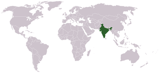
Location map for w:India.
User:dbenbenn modified Image:BlankMap-World.png.
授權條款
| |
此作品已由其作者,中文維基百科專案的Vardion,釋出至公有領域。此授權條款在全世界均適用。 如果法律不適用時: |
檔案歷史
點選日期/時間以檢視該時間的檔案版本。
| 日期/時間 | 縮圖 | 尺寸 | 使用者 | 備註 | |
|---|---|---|---|---|---|
| 目前 | 2021年9月11日 (六) 15:35 | | 1,357 × 628(21 KB) | Ytpks896 | Reverted to version as of 22:39, 12 February 2005 (UTC) |
| 2021年7月29日 (四) 21:37 |  | 1,427 × 628(103 KB) | Ytpks896 | Reverted to version as of 03:16, 1 May 2008 (UTC) | |
| 2010年2月15日 (一) 08:33 |  | 1,357 × 628(24 KB) | King Zebu | Reverted to version as of 09:17, 3 June 2005 Please discuss before making such edits in future. | |
| 2008年5月1日 (四) 11:16 |  | 1,427 × 628(103 KB) | KAVO | (Changed to colours more noticeable: *Light green - Claimed by India, not administered by India **(Aksai Chin, Azad Kashmir, Northern Areas, Shaksgam Valley) *Deep Green - Disputed with other nations, administered by India **(Arunachal Pradesh, Jammu and | |
| 2005年6月3日 (五) 17:17 |  | 1,357 × 628(24 KB) | Nichalp | NPOV map, please discuss any changes with me for NPOV status | |
| 2005年2月13日 (日) 06:39 |  | 1,357 × 628(21 KB) | Dbenbenn | higher resolution version, without black border | |
| 2004年12月6日 (一) 04:28 |  | 250 × 115(18 KB) | EugeneZelenko | Location map for India.<br/>Originally created for English Wikipedia by Vardion.<br/>{{GFDL}} |
檔案用途
下列頁面有用到此檔案:
全域檔案使用狀況
以下其他 wiki 使用了這個檔案:
- ar.wikinews.org 的使用狀況
- ckb.wikipedia.org 的使用狀況
- en.wikipedia.org 的使用狀況
- en.wikinews.org 的使用狀況
- en.wikivoyage.org 的使用狀況
- en.wiktionary.org 的使用狀況
- fr.wikinews.org 的使用狀況
- fur.wikipedia.org 的使用狀況
- he.wikivoyage.org 的使用狀況
- hr.wikipedia.org 的使用狀況
- hr.wikiquote.org 的使用狀況
- incubator.wikimedia.org 的使用狀況
- ko.wikipedia.org 的使用狀況
- li.wikinews.org 的使用狀況
- pam.wikipedia.org 的使用狀況
- pl.wiktionary.org 的使用狀況
- ps.wikivoyage.org 的使用狀況
- pt.wikivoyage.org 的使用狀況
- pt.wiktionary.org 的使用狀況
- sr.wikibooks.org 的使用狀況
- sv.wikinews.org 的使用狀況
檢視此檔案的更多全域使用狀況。