
File:Angola Regions map.png

預覽大小:583 × 599 像素。 其他解析度:234 × 240 像素 | 467 × 480 像素 | 747 × 768 像素 | 996 × 1,024 像素 | 2,500 × 2,569 像素。
原始檔案 (2,500 × 2,569 像素,檔案大小:1.3 MB,MIME 類型:image/png)
摘要
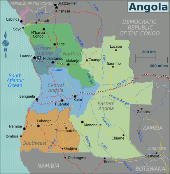
| 描述 | Regional map of Angola (Wikivoyage regional scheme), English version |
| 日期 | |
| 來源 | own work based on the Perry-Castañeda Library Map Collection Angola Maps |
| 作者 | Burmesedays |
| 其他版本 |
授權條款
此檔案採用創用CC 姓名標示 3.0 未在地化版本授權條款。
- 您可以自由:
- 分享 – 複製、發佈和傳播本作品
- 重新修改 – 創作演繹作品
- 惟需遵照下列條件:
- 姓名標示 – 您必須指名出正確的製作者,和提供授權條款的連結,以及表示是否有對內容上做出變更。您可以用任何合理的方式來行動,但不得以任何方式表明授權條款是對您許可或是由您所使用。
原始上傳日誌
| This file was imported from Wikivoyage WTS. |
原始描述頁面位於這裡。下列使用者名稱均來自wts.wikivoyage-old。
- 2010-01-27 09:21 (WT-shared) Burmesedays[失效連結] 2500×2569 (1320997 bytes) {{Imagecredit|credit=[[user:burmesedays]], [http://www.lib.utexas.edu/maps/angola.html Perry-Castañeda Library Map Collection Angola Maps]| (Import from wikitravel.org/shared)
- 2010-04-25 08:34 (WT-shared) Burmesedays[失效連結] 2500×2569 (1363787 bytes) minor fixes (Import from wikitravel.org/shared)
檔案歷史
點選日期/時間以檢視該時間的檔案版本。
| 日期/時間 | 縮圖 | 尺寸 | 使用者 | 備註 | |
|---|---|---|---|---|---|
| 目前 | 2013年1月20日 (日) 09:28 | | 2,500 × 2,569(1.3 MB) | Peterfitzgerald | Rename: Central Highlands → Central Angola, split off Lunda Norte & Lunda Sul from North, merge with southwest into new Eastern Angola region. |
| 2012年11月21日 (三) 11:48 |  | 2,500 × 2,569(1.3 MB) | OgreBot | (BOT): Reverting to most recent version before archival | |
| 2012年11月21日 (三) 11:48 |  | 2,500 × 2,569(1.26 MB) | OgreBot | (BOT): Uploading old version of file from wts.wikivoyage; originally uploaded on 2010-01-27 09:21:48 by (WT-shared) Burmesedays | |
| 2012年11月18日 (日) 05:19 |  | 2,500 × 2,569(1.3 MB) | MGA73bot2 | {{BotMoveToCommons|wts.oldwikivoyage|year={{subst:CURRENTYEAR}}|month={{subst:CURRENTMONTHNAME}}|day={{subst:CURRENTDAY}}}} == {{int:filedesc}} == {{Information |description=Map of Angola. Map of Angola, Angola * Map of: Angola¤ |date=January 27th 201... |
檔案用途
下列頁面有用到此檔案:
全域檔案使用狀況
以下其他 wiki 使用了這個檔案:
- el.wikivoyage.org 的使用狀況
- en.wikivoyage.org 的使用狀況
- fr.wikivoyage.org 的使用狀況
- he.wikivoyage.org 的使用狀況
- incubator.wikimedia.org 的使用狀況
- it.wikivoyage.org 的使用狀況
- ja.wikivoyage.org 的使用狀況
- pt.wikivoyage.org 的使用狀況
- vi.wikivoyage.org 的使用狀況