
File:Fergana valley topo political.png
没有更高的分辨率。
Fergana_valley_topo_political.png (375 × 178像素,文件大小:136 KB,MIME类型:image/png)
| 描述 |
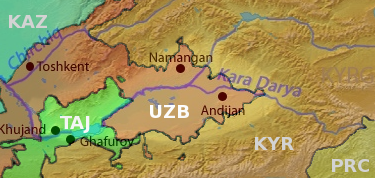
English: Map of the Fergana valley (highlighted) in Central Asia, national territories color coded, with shortened names, using boundaries from CIA 2001 Map File:Tajikistan_2001_CIA_map.jpg |
| 日期 | (UTC) |
| 来源 | |
| 作者 |
|
| 这是一张修改过的图片,这意味着它已在原版本的基础上通过软件进行了编辑,改动内容:Overlay national territories, highlight Fergana Valley。其原始版本为:Syrdaryamap.png。修改者: T L Miles。
|
我,本作品著作权人,特此采用以下许可协议发表本作品:
- 您可以自由地:
- 共享 – 复制、发行并传播本作品
- 修改 – 改编作品
- 惟须遵守下列条件:
- 署名 – 您必须对作品进行署名,提供授权条款的链接,并说明是否对原始内容进行了更改。您可以用任何合理的方式来署名,但不得以任何方式表明许可人认可您或您的使用。
- 相同方式共享 – 如果您再混合、转换或者基于本作品进行创作,您必须以与原先许可协议相同或相兼容的许可协议分发您贡献的作品。

|
已授权您依据自由软件基金会发行的无固定段落及封面封底文字(Invariant Sections, Front-Cover Texts, and Back-Cover Texts)的GNU自由文件许可协议1.2版或任意后续版本的条款,复制、传播和/或修改本文件。该协议的副本请见“GNU Free Documentation License”。 |
您可以选择您需要的许可协议。
原始上传日志
This image is a derivative work of the following images:
- File:Syrdaryamap.png licensed with Cc-by-sa-3.0,2.5,2.0,1.0, GFDL
- 2010-02-07T03:04:09Z Shannon1 1101x866 (1580396 Bytes) {{Information |Description={{en|1=Map of the watershed of the Syr Darya in Central Asia, that drains to the Aral Sea.}} |Source=Background and river course data from http://www2.demis.nl/mapserver/mapper.asp |Author=Backgrou
Uploaded with derivativeFX
文件历史
点击某个日期/时间查看对应时刻的文件。
| 日期/时间 | 缩略图 | 大小 | 用户 | 备注 | |
|---|---|---|---|---|---|
| 当前 | 2010年6月15日 (二) 03:39 | | 375 × 178(136 KB) | T L Miles | {{Information |Description={{en|1=Map of the watershed of the Syr Darya in Central Asia, that drains to the Aral Sea.}} |Source=*File:Syrdaryamap.png |Date=2010-06-14 19:38 (UTC) |Author=*File:Syrdaryamap.png: Background layer attributed to DE |
文件用途
以下页面使用本文件:
全域文件用途
以下其他wiki使用此文件:
- da.wikipedia.org上的用途
- de.wikipedia.org上的用途
- de.wikivoyage.org上的用途
- en.wikipedia.org上的用途
- en.wikivoyage.org上的用途
- fa.wikipedia.org上的用途
- fi.wikipedia.org上的用途
- hi.wikipedia.org上的用途
- it.wikipedia.org上的用途
- ml.wikipedia.org上的用途
- mn.wikipedia.org上的用途
- ms.wikipedia.org上的用途
- pl.wikipedia.org上的用途
- ro.wikipedia.org上的用途
- sv.wikipedia.org上的用途
- ta.wikipedia.org上的用途
- te.wikipedia.org上的用途
- th.wikipedia.org上的用途
- tl.wikipedia.org上的用途
- uk.wikipedia.org上的用途