
File:Îles d'Hyères topographic map-fr.svg

此SVG文件的PNG预览的大小:784 × 337像素。 其他分辨率:320 × 138像素 | 640 × 275像素 | 1,024 × 440像素 | 1,280 × 550像素 | 2,560 × 1,100像素。
原始文件 (SVG文件,尺寸为784 × 337像素,文件大小:1.84 MB)
摘要
| 相机位置 | | 在以下服务上查看本图像和附近其他图像: OpenStreetMap |
|---|
| 描述 |
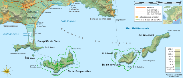
Français : Carte topographique et administrative en français des Îles d'Hyères.
Deutsch: Topographische Karte / Verwaltungskarte zum Îles d'Hyères, in Französische
English: Topographic and administrative map in French language of Îles d'Hyères
Italiano: Carta topografica e amministrativa delle Isole di Hyères (en francese)
|
||
| 日期 | (UTC) | ||
| 来源 |
Création personnelle ;
|
||
| 作者 | Bourrichon (talk) - fr:Bourrichon | ||
| 授权 (二次使用本文件) |
|
||
| 其他版本 |
Add-your-version : Template:Other versions/Îles d'Hyères map
|


|
This SVG file contains embedded text that can be translated into your language, using any capable SVG editor, text editor or the SVG Translate tool. For more information see: About translating SVG files. |
许可协议
我,本作品著作权人,特此采用以下许可协议发表本作品:

|
已授权您依据自由软件基金会发行的无固定段落及封面封底文字(Invariant Sections, Front-Cover Texts, and Back-Cover Texts)的GNU自由文件许可协议1.2版或任意后续版本的条款,复制、传播和/或修改本文件。该协议的副本请见“GNU Free Documentation License”。 |
- 您可以自由地:
- 共享 – 复制、发行并传播本作品
- 修改 – 改编作品
- 惟须遵守下列条件:
- 署名 – 您必须对作品进行署名,提供授权条款的链接,并说明是否对原始内容进行了更改。您可以用任何合理的方式来署名,但不得以任何方式表明许可人认可您或您的使用。
- 相同方式共享 – 如果您再混合、转换或者基于本作品进行创作,您必须以与原先许可协议相同或相兼容的许可协议分发您贡献的作品。
您可以选择您需要的许可协议。
文件历史
点击某个日期/时间查看对应时刻的文件。
| 日期/时间 | 缩略图 | 大小 | 用户 | 备注 | |
|---|---|---|---|---|---|
| 当前 | 2018年8月23日 (四) 19:40 | | 784 × 337(1.84 MB) | Bourrichon | +extension des limites du parc national : ajout de l'île de Porquerolles |
| 2011年8月19日 (五) 21:53 |  | 784 × 337(1.83 MB) | Bourrichon | == {{int:filedesc}} == {{Location|20|15|00|S|57|35|00|E|scale:500000}} {{Information |Description= {{fr|Carte topographique et administrative en français des Îles d'Hyères.}} {{de|Topographische Karte / Verwaltungskarte zum [[: |
文件用途
以下页面使用本文件:
全域文件用途
以下其他wiki使用此文件:
- cs.wikipedia.org上的用途
- da.wikipedia.org上的用途
- de.wikipedia.org上的用途
- en.wikipedia.org上的用途
- en.wikivoyage.org上的用途
- fr.wikipedia.org上的用途
- Conservatoire du littoral
- Parc national de Port-Cros
- Presqu'île de Giens
- Îles d'Hyères
- Utilisateur:Flappiefh/Bac à sable/Images à améliorer/Contenu visiteur
- Wikipédia:Atelier graphique/Cartes/Archives/septembre 2011
- Rade d'Hyères
- Wikipédia:Atelier graphique/Cartes/Archives/octobre 2016
- Golfe de Giens
- fr.wiktionary.org上的用途
- ja.wikipedia.org上的用途
- la.wikipedia.org上的用途
- nn.wikipedia.org上的用途
- oc.wikipedia.org上的用途
- pl.wikipedia.org上的用途
- pt.wikipedia.org上的用途
- ru.wikipedia.org上的用途
- www.wikidata.org上的用途
- zh.wikipedia.org上的用途